Monday, September 7, 2009

Baguio Maps

Baguio City Road Map 1

Here's one that contains ia lot of information, including icons that indicate buildings, mostly government, medical & educational institutions. Some street names are not very easy to find, in my opinion because, they are just indicated by arrows pointing to the roads.


Baguio City Road Map 2

An older map, this one I like because it shows the major tourist attractions, points of interest and residential areas of the Summer Capital of the Philippines and is not cluttered by too much information so major street names are easy to find.


Baguio City Road Map 3


This one is very useful because it contains as shaded rectangle that shows the Central Business District area subject to the Number Coding Scheme. Like the one above it show the names of major roads.


Baguio City Area Map


This one shows the location of the City of Pines in relation to the Benguet and La Union provinces in the Philippines. The red lines indicate access roads to the Summer Capital (e.g. Naguilian Road, Marcos Highway & Kennon Road partially.

Friday, September 4, 2009

Baguio Attractions and Historical Landmarks


Baguio City probably has the largest number of visitor attractions clustered in a relatively small area compared to other tourist destinations in the Philippines. The most popular tourist attractions are located near each other, on the East and South sides, although there are a few near the residential areas. Just 8.2 km from east to west and 7.2 km from north to south and with inexpensive public transportation available, it is one of the easiest places to explore.
The first thing to do when touring is to buy a map ($1-$3 at the nearest gas station, bookstore). I suggest you select a map that marks or indicates the attractions I will be enumerating below, so you have an option of exploring Baguio on your own instead of taking a guided tour. That would save you more money -- to spend shopping instead! It would be good if you checked out Travel Tips for Baguio Visitors, too.


Burnham Park
Burnham Park is Baguio City's premier park. While Manila has Luneta or Rizal Park, Baguio City has Burnham Park. Named in honor of its planner and architect, Daniel Burnham, Burnham park is the most popular park in Baguio City.Around the park are the children's playground, biking area, orchidarium, football ground, skating rink, tennis court, basketball court and a few restaurants. The place gets so much visitors during the summer particularly the Holy Week and during Christmas season. By tradition, people flock to Burnham park on Christmas and New Year's day for picnics.

In the middle of the park is a man-made lake where you can go boating. If you'd rather savor the view of the lake or its beautiful surroundings, you can just walk around, enjoy the flowers, take pictures or probably just have a seat in one of the benches and watch. Baguio Cathedral

The Baguio Cathedral sits on top of a hill called by Belgian Catholic Mission as Mount Mary. The Baguio cathedral served as evacuation center and shelter during World War II withstanding Japanese carpet bombing, saving thousands of lives. Beside the Baguio Cathedral is a parking lot that also serves as a view deck for Baguio's surroundings including the Baguio Athletic Bowl, Burnham Park, Mount Sto Tomas, Baguio City Hall.


The Mansion


The official summer residence of the President of the Philippines. The main gate is an exact replica of the one found in Buckingham Palace in London.


Wright Park


The "Pool of Pines" or better known as Wright Park features a shallow elongated rectangular man-made pool of water. It was named after the architect, Governor Luke E. Wright (who ordered architect Daniel Burnham to build Baguio as a recreational facility for American soldiers and civilians).


Camp John Hay


Used to be an American military recreational camp during World War II, Camp John Hay is now a popular destination for people who wish to see the pine forests in the city. The place also boasts a sprawling country club with a full 18-hole golf course as well as many trendy restaurants and a nice hotel.


Session Road


Baguio City's modern commercial area started here. Therefore, expect to find some of the oldest and newest restaurants, bazaars, banks, private offices and many more. More importantly, Session Road serves as the center or starting point for staging the city's various festivities such as the very successful Panagbenga, Alumni Homecoming parades from various schools and others. The foot of Session Road starts from Maharlika Building perpendicular to Magsaysay Rd. From there, it goes all the way up to the ever-familiar Shoemart, where the former famous Pines Hotel used to be located.

Mines View Park


Mines View Park is one of the most frequented tourist spots in Baguio City. The park has a viewdeck where one can have an unobstructed view of Balatok, Antamok and Atok mines and a spectacular view of the Cordillera mountain range. These mines used to be rich in gold and copper. Within the area are souvenir shops where you can find locally-made souvenirs, home decor items, handmade jewelleries, food items that may be found only in Baguio City.


Botanical Garden


The Botanical Garden showcases huts of typical Igorot design. Around the park are trees and flowering plants that you can enjoy by walking thru stone-paved pathways. Inside the Botanical Garden, you can also find locally made artworks and some souvenir items. To get to the Botanical Garden, you follow Leonard Wood Rd, the same road going Saint Joseph church, Pacdal horseback riding grounds, Wright Park, Mansion House and Mines View Park. If coming from the city proper, it is found on the right side just after Teacher's Camp and before reaching Saint Joseph church or Pacdal Circle.

Tuesday, September 1, 2009

Enjoy Baguio!


Ours is a tiny mountain resort town with a big reputation. Baguio is gifted with a variety of cultural, historical and scenic attractions that make it an important and interesting destination, favorited by local and foreign tourists, whole families on vacation, honeymoon couples and large convention groups.

Boasting great natural beauty, chilly weather, a tourist-friendly people and extraordinary vistas, the City of Pines is the culmination of your search for the idyllic escape from the tropical heat of the Philippine lowlands.


Geography

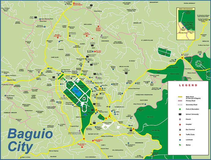
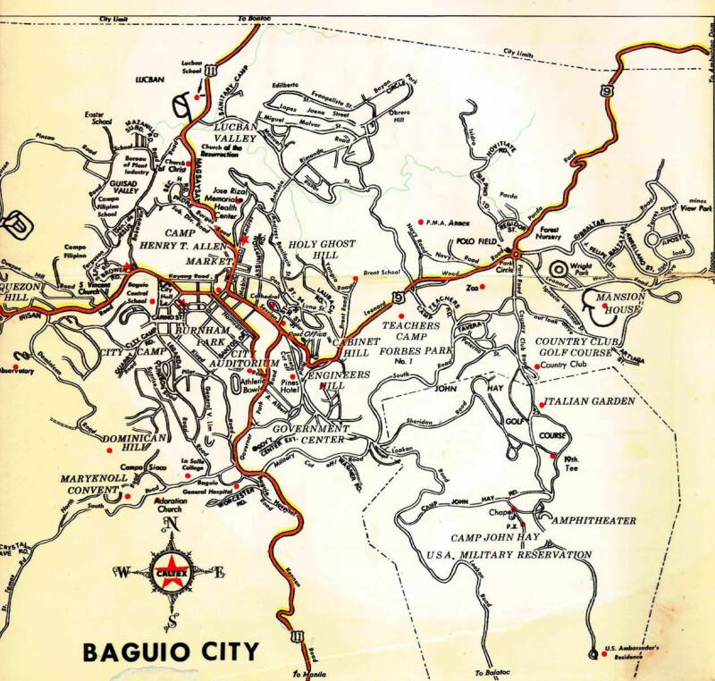
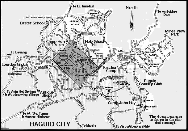
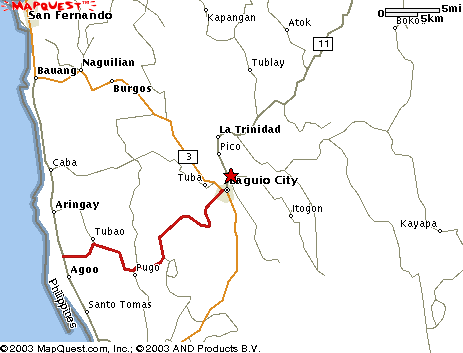
Baguio City occupies about 57 square kilometers of hilly land about 1,524 meters high in the southwestern portion of the Cordillera Central mountain range in northern Luzon in the Philippines. It is completely surrounded by the province of Benguet, which Baguio used to be a town of before being made into an independent city. It is bordered by the municility of Tuba to the south and west, by Itogon to the east and to the north by Benguet's capital, La Trinidad.


Climate

The average temperature is from 15-26˚C, and it can drop down to 8˚C from December to early February. The weather follows the typical Philippines' seasons: Dry Season from October to May and the Wet Season from June to September.
In general, Baguio is 8˚ cooler any month compared to any place in the Philippine lowlands. When Manila heats up at at 35˚C, Baguio seldom exceeds 26˚C at its warmest. The lowest temperature reading made was 6.27˚C, recorded in January 18, 1961. Recently, on January 29, 2007, the temperature dropped to a chilly 7˚C.
Baguio can get pretty damp and foggy during the Philippines' rainy season, with the largest amount of rainfall in the country, due to the high altitude and the heavily forested areas of the Cordillera mountain range. The record for the heaviest volume of rainfall occurred in July 1927 when it measured 4.77 meters.
In November, wild sunflowers appear on the hillsides signaling the end of the rainy season, and Baguio becomes a tropical paradise until May. Christmas season is when it glows with the nippy wintry air, and coats, hats and scarves are the outfits of choice.


Location:
240 km north of Manila


Land Area:
57.49 square km
8.2 km east to west
7.2 km north to south


Climate:

Temperature is 15-26˚C, can drop down to 8˚C
Dry Season from October to May
Wet Season from June to September


Population:
280,756 persons based on the 2005 survey per barangay; more than 45% are students


Language / Dialect:
English widely used
Ilocano - 55%
Tagalog - 25%
Other dialects - 20%


Currency:
Philippine Peso (Php) in denominations of 1000, 500, 200, 100, 50, 20, 10, 5, 1 in pesos and 25, 10, 5 and 1 in centavos.


Economy: Tourism

Baguio retains its title as the Summer Capital of the Philippines no longer because it is the seat of government in April and May, but because its cool temperature is a much needed respite from the tropical heat that the rest of the country endures on those months.

It is a favorite vacation place for Filipino families, balikbayans (Filipinos returning from living and working overseas), American tourists nostalgic for the country's "Little America," and other foreign guests who want to sample an altogether different Philippine setting. On all other months, Baguio is converted to "Convention City," boasting of several convention centers and conference halls that can accommodate up to 4,000 guests at a time.


Economy: Education

The past decade has seen a surge in the student population of Baguio as schools have been mush-rooming all over the city, and as same-sized campuses have been permitted an unham-pered increase in enrollment.

This massive number of transient residents has adversely affected tourism because of the congestion of the city center where most schools are located. This has also led to an overpopulation of Baguio (as it was designed originally for just 30,000 residents), as well as the rapid depletion of its natural resources.

One big source of revenue for the city is the proliferation of Korean English Academies. Though their actual population is unknown, just a cursory look around at all the business signages with Korean characters, as well the Koreans walking around on weekends, will reveal that they are here in great numbers.

Economy: Exports & Manufacturing

Baguio Export Processing Zone

The home of garments factories, Texas Instruments Philippines and Moog Controls Corporation, BEPZ is responsible for generating jobs for the locals as well as contributing to a great extent to the Gross National Product of the Philippines.

Woodcarvers & Weaving

Another source of exports are the works of ethnic woodcarving and weaves that are sought after in the international market.


Agricultural Products

Baguio is the best and primary source of highland vegetables such as lettuce, broccolli, cauliflower, carrots, potatoes, cabbage, and other greens. All these come from the different Cordillera provinces, are brought to La Trinidad Valley and are retailed at the very popular Baguio City Market.


Service Providers

Recently, due to the huge population of fresh graduates from the local schools and universities here, there has been an influx of call centers in the city with international companies outsourcing their technical support facilities in the Philippines.